


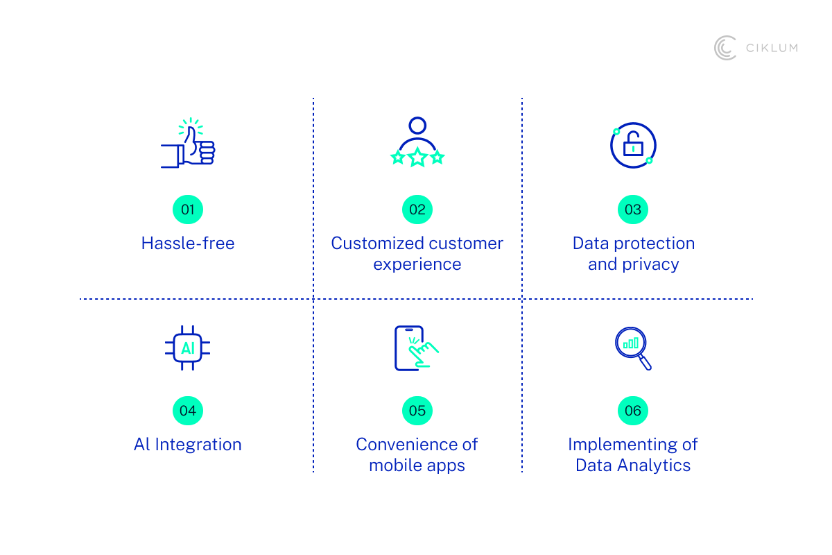
Key Takeaways:
- Unpredictable climate is accelerating demand for GIS data in the insurance industry
- Real-time mapping enables smarter, faster decisions.
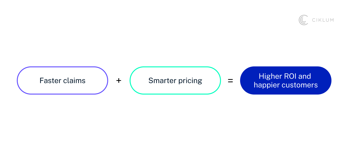
- Increased ROI through precise risk assessment and faster claims
The Digital Revolution in Insurance
In today’s digital-first world, the insurance industry faces new challenges: rising risk from climate change and evolving customer expectations. One tool that’s helping them overcome these challenges is Geographic Information Systems (GIS). In insurance, data derived through GIS applications enables smarter underwriting, faster claims validation, and sharper risk visibility.
But it’s not just about risk. Policyholders now demand more personalization, transparency, and a stronger sense of trust with their insurer. According to Twilio Segment, 62% of business leaders say personalization has helped them retain customers. To meet these expectations, insurers must rethink their approach, leveraging tools like GIS to provide more accurate risk assessments, better customer engagement, and greater trust.
In this blog, we’ll break down everything you need to know about GIS in insurance, its core components, real-world challenges, and how to implement it in your business.
How GIS Changed the Game
Initially, insurers adopted traditional approaches such as manually gathering information or relying on historical data. These approaches were slow and had limited accuracy. GIS data changed that by bringing location intelligence to real-time decision-making. Through this change, companies have started driving meaningful impact.
Consider a scenario where, after a natural disaster, customers used to wait days for a claims response. Now, with access to GIS data, insurers can easily assess damage, verify claims, and deliver support almost immediately.
Why Does GIS Matter Now?
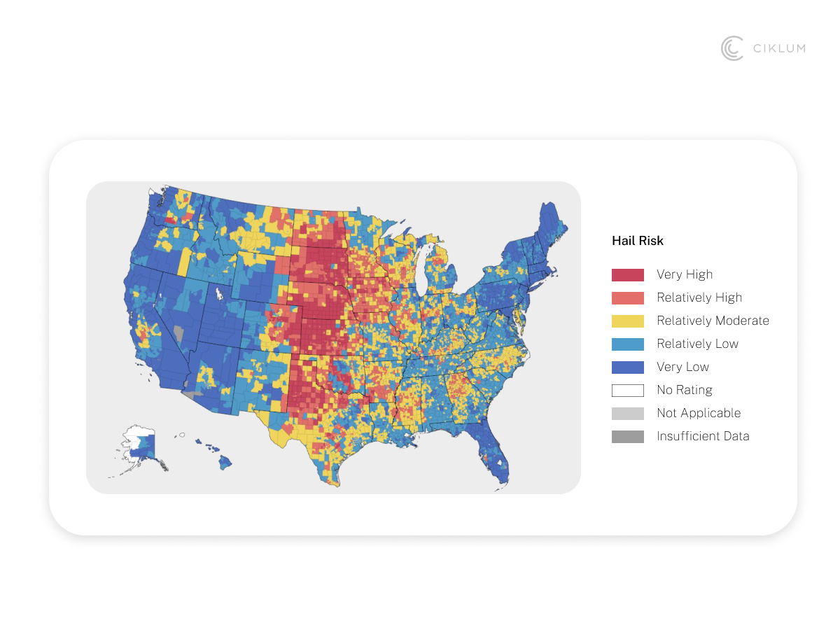
Floods, wildfires, and extreme weather events are more unpredictable than ever. It’s no longer easy to tell where or when the next disaster will strike. GIS removes this uncertainty for insurance companies. With advanced mapping data, you can identify high-impact flood zones, track wildfire paths, and pinpoint high-risk areas before disaster hits. In an already volatile climate, such clarity helps insurance companies make the right decisions at the right time. This also helps insurance firms with a stronger risk assessment and the right pricing decisions during policy issuance.
Understanding GIS Data and Its Role in Insurance
GIS data is any information linked to specific geographic locations. Think exact coordinates of a property, the shape of a floodplain, or the path of a wildfire. When mapped digitally, it gives you a real-time view to detect patterns for further climate risk analysis. It’s geography in motion.
Modern GIS integrates AI, machine learning capabilities, and cloud platforms to power three critical layers:
- Spatial Data – Pinpoints the exact location or boundaries of features like roads or flood zones.
- Attribute Data – Describes what exists at those locations, such as risk level.
- Temporal Data – Tracks when events occur, like wildfire spread or flooding.
How GIS Enhances Traditional Insurance Models
Precision matters a lot in insurance. Traditional models, relying on static risk maps and regional averages, no longer make it in today’s ever-changing climate. So, how does GIS change that?
Consider two homes in the same neighborhood, but situated at different elevation levels. Traditional models might rate them with the same flood risk. But with real-time data through GIS, insurers can assess each property’s true risk. This shows how geospatial innovation makes a difference in insurance.
Key Applications of GIS in the Insurance Industry
Let’s understand how GIS data is bringing value to the insurance industry:
Risk Assessment and Underwriting Innovation
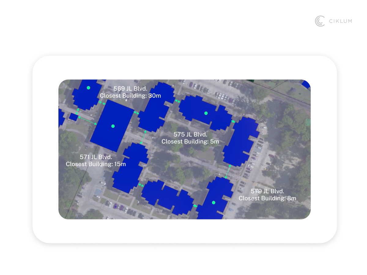
When there’s a risk of a natural disaster, GIS gives insurers a high-resolution view of the physical environment. This helps them calculate the exact distance between a structure and nearby water bodies, offering a clearer picture of potential damage.
For underwriters, this means moving from generalized assessments to hyper-specific, address-level analysis. It’s a smarter approach, especially when over $43 billion in flood risk across the U.S. remains uninsured due to outdated models.
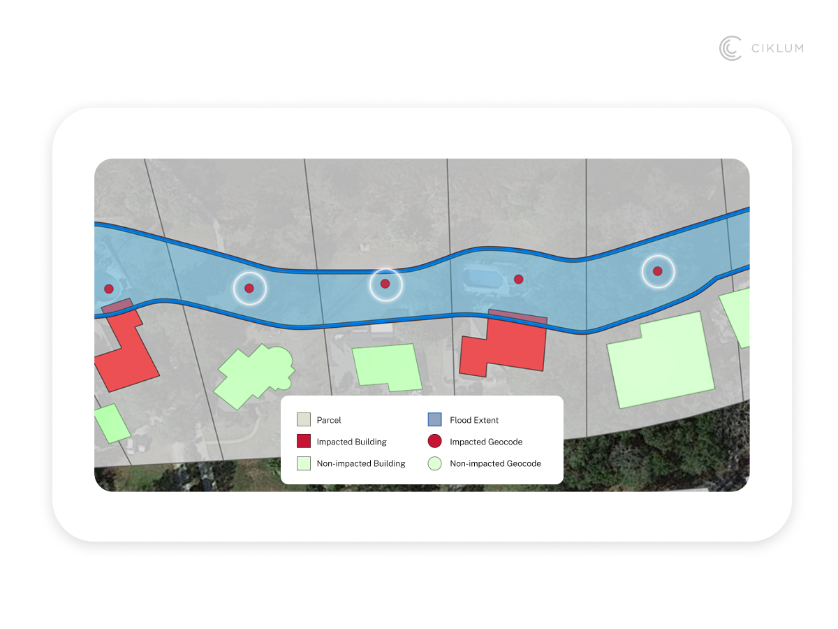
Claims Processing and Catastrophe Management
Fraudulent claims are costly, and they should be avoided at all costs. GIS helps insurers validate claims quickly and accurately. Through real-time satellite imagery and drone data, you can confirm whether a property was within the impact zone of a natural disaster.
This becomes even more important when multiple claims arise from the same region. GIS data can save millions of dollars by detecting suspicious patterns, automating damage mapping, and prioritizing high-risk claims.
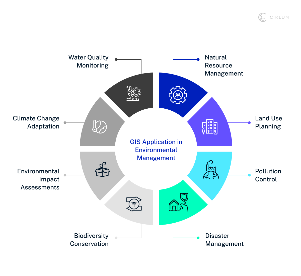
Enhancing Customer Engagement and Personalization
GIS allows insurers to deliver real-time, location-based alerts during high-risk events. With a clear view of geographic risk factors, insurers can offer coverage that fits the customer’s situation rather than relying on a one-size-fits-all approach. These personalized touches build trust and reinforce the insurer’s role as more than just a claims handler. For a closer look at the importance of tailored experiences, don’t miss our deep dive on how customized experiences can transform financial services.
Implementation Strategies and Best Practices
Take a look at how GIS can be integrated into existing insurance systems and overcome challenges.
Building a GIS-Enabled Insurance Platform
First, identify what needs to be solved, whether it’s improving risk assessment or claims handling. Then, choose a GIS platform that suits your needs and consider integrating AI and machine learning to extract deeper insights. When the platform is set up, you can train your team to ensure that no hiccups remain before scaling. The key is to build a GIS-enabled platform that evolves with your business.
Overcoming Challenges
It’s common to face challenges like inaccurate data, integration issues, and high costs when implementing GIS. Partnering with a geospatial data expert can guide you through the process. Once you get the hang of GIS, you'll have access to high-quality data, leading to more reliable insights with less back-and-forth.
Measuring ROI and Business Impact
GIS data has a direct impact on ROI. Once fully integrated into your business, GIS helps price policies better, reduce claim processing times, and automate repetitive tasks. These improvements lead to happier customers, which drives more profitability for your insurance business.
Conclusion: The Ciklum Approach to Digital Transformation in Insurance
As climate risks intensify, insurance companies can no longer afford to ask whether to leverage GIS data. But how soon they can make it count. The power of GIS lies in its ability to turn raw geospatial data into information that drives transformation for your business. And in the insurance industry, its potential? Nothing short of transformative.
When you partner with a global company like Ciklum, you're working with deep technical experts who know how to make GIS work for you. We have the people and solutions to help your insurance business scale faster and deliver personalized customer experiences.
With our Experience Engineering approach, we ensure your GIS platforms solve real-world problems.
Explore our banking and finance solutions or talk to our experts to discuss your specific needs.
By Ciklum Editorial Team

Ciklum’s Editorial Board is a collective of experienced writers and industry experts, bringing together perspectives shaped by real-world engineering and delivery experience. Through collaborative insights, the team explores how technology, AI, and digital innovation move from concept to execution across industries.
Blogs
Discover Similar Insights

AI Automation in BFS: Strengthening Compliance, Fraud Prevention, and CX
Learn More
Payments Without Friction: Modern Checkout Is Your Competitive Edge
Learn More
How to Choose a Software Development Company in 2025
Learn More
Best Practices for Protecting Data on Connected Devices in Hitech
Learn More